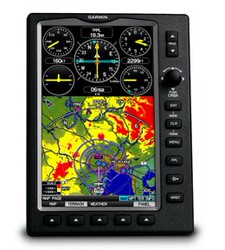
Garmin Aera 795 Air GPS Spot Бесплатная доставка!

Вес товара: ~0.7 кг. Указан усредненный вес, который может отличаться от фактического. Не включен в цену, оплачивается при получении.
Описание товара
- Информация о товаре
- Фотографии
Garmin Ara 795 Air GPS Spot бесплатная доставка
Garmin Airlines Aera 795
I. Обзор
Aera 795даGarminкомпания2012Последний год7Навигация на сенсорный экран дюймаGPSпродукт.Виртуальный аэропорт3DНавигация и препятствия для реальной сцены показывают, что безбумажные авиационные журналы делают ваш парус более безопасным и удобным.
Experience 3-D navigation, advanced electronic flight bag capabilities and more with aera 795. Viewable in both portrait and landscape mode, the device’s 7” touchscreen puts a wealth of flight information right at your fingertips.
виртуальный3Dпейзаж
Revolutionary new 3D Vision technology shows a virtual 3-D behind-the-aircraft perspective of surrounding terrain derived from GPS and the onboard terrain database– a feature previously only available in our panel-mount avionics. Simply slide your finger across the touchscreen to rotate the view and show land and water features, obstacles, runways and airport signposts in relative proximity to the aircraft. Using its forward-looking terrain avoidance capability, aera 795 predicts in advance where towers or obstacles may exist and shades the landscape with amber or red overlays to indicate those areas. 3D Vision and other flight data are presented smoothly and continuously thanks to the device’s internal GPS that provides position updates 5 times per second (5 Hz).
aera 795’s bright 7" diagonal high-definition sunlight-readable display makes this detailed mapping easy to see in any lighting conditions and works in both portrait and landscape mode. The physical design has been optimized to fit on the yoke or for use as a knee-mounted device. There are only 4 touch keys on the bezel representing"Back","Menu","Direct-to" and"Nearest" for quick navigation to the most frequent used functions. All other functions are quickly accessed through Intuitive onscreen icons with labels. This unique touchscreen interface even allows you to quickly pan across the map screen and pinch to zoom.
Безбумажный полет
aera 796 fullfills the role of either a Class I or Class II electronic flight bag, greatly reducing the need to rely on paper charts in the cockpit. Initial georeferenced VFR sectional and IRF enroute charts come preloaded that show your aircraft’s position overlaid directly on the relevant chart. When in IFR map mode, the 795 can display victor airways, jet routes, minimum enroute altitudes and leg distance, much like what’s found on traditional enroute charts. Initial georeferenced Garmin FliteCharts provide approach charts and airport diagrams for the U.S., while pilots who prefer Jeppesen charts and diagrams can use optional Garmin ChartView service, which utilizes Jeppesen’s extensive library to provide global georeferenced charting capabilities. aera 795 also includes a robust document viewer, so you can easily pull up weights and balances, flight manuals, raster charts or a wide range of electronically formatted materials you download to the device. A“scratch pad” feature also allows you to quickly jot down clearances and other pertinent notes while in route, while a checklist viewer allows you to create customized and interactive electronic checklists.
Увеличение идентификации окружающей среды
aera 795’s built-in terrain and obstacle database not only shows contours in 3D Vision mode, but also allows for a top-down view of your entire route. To help you navigate around unfamiliar airports, SafeTaxi? provides detailed taxiway diagrams and position information for over 1,000 U.S. airports, while a private airport and heliport database greatly expands your emergency“nearest” options. FBO, ground transportation, lodging and other facility information for most U.S. airports are also available through preloaded AOPA Airport Directory Data; international pilots may choose to opt for global
AC-U-KWIK airport directory data instead
Более портативно
Thanks to its 2 serial ports, aera 795 allows for simultaneous connectivity with other hardware. With an optional Garmin GTX 330 Mode S Transponder Interface, you can access Traffic Information Service (TIS) alerts, where available, right on the device while also sending frequencies to a Garmin SL30/40 radio or relaying position reports to other devices.
By adding optional City Navigator maps, both helicopter and fixed-wing pilots add street addresses as waypoints or direct-to destinations. The device includes an SD? card slot for easy updates and expansions; easily keep track of the databases on your aera through flyGarmin, our online manager that helps you update, manage and purchase the latest aviation data for your Garmin device
3. Техническая производительность
Аппаратное обеспечение и производительность: | |
| Размер, длинный х широкий x высота: | 5.1"W x 8.0"H x 1.5"D (13.0 x 20.3 x 3.8 cm) |
| Размер дисплея, длинный х широкий: | 3.6"W x 6.0"H (9.1 x 15.2 cm); 7.0" diag (17.78 cm) |
| Разрешение, длинный х широкий: | 480 x 800 pixels |
| Тип дисплея: | dual-oriented, bright, color WVGA TFT with adjustable backlighting and selectable screen orientation |
| масса: | 26.4 ounces (748 g) with battery pack; 18.3 ounces (519 g) without battery pack; 12.7 ounces (361 g) RAM mount |
| Батарея: | rechargeable, replaceable Lithium-ion |
| Время использования батареи: | up to 3 hours with full backlight and GXM 40 connected (8 hours with 50% backlighting and XM connected) |
| водонепроницаемый: | никто |
| Диапазон напряжения: | 11-40 |
| Получатель: | high-sensitivity with WAAS position accuracy |
| IFR или VFR: | VFR |
Карты, базы данных и хранение: | |
| Электронная нижняя карта: | иметь |
| Jeppesen&Reg; база данных: | иметь |
| Тип базы данных Jeppesen: | full and ARTCC, FSS frequencies and final approach waypoints |
| Jeppesen Database Область охвата базы данных: | Americas |
| Предварительно установленная топографическая карта: | иметь |
| Предварительные данные препятствий: | yes (U.S. and Europe only) |
| SafeTaxi&торговля; карта аэропорта: | yes (U.S. only) |
| Справочник аэропорта AOPA: | yes (U.S. only) |
| Предварительно установленный Garmin Flitecharts®: | yes (U.S. only) |
| Preloaded low& high altitude enroute airways: | иметь |
| Preloaded private airports: | yes (U.S. only) |
| Предварительная карта: | никто |
| Можно добавить с помощью карт: | иметь |
| Поддержка карты памяти: | yes (SD cards) |
| Объем памяти: | internal solid state |
| Воздушная точка/зажим для сбора/позиция: | 3,000 |
| маршрут: | 50 |
особенность: | |
| Мобильная карта: | иметь |
| Страница инструмента: | иметь |
| Встроенный -ин -in hsi: | иметь |
| Режим карты IFR: | иметь |
| совместимый“ Служба информации о трафике” (tis) тревога: | иметь |
| Звуковая тревога Topen: | иметь |
| Terrain resolution: | standard |
| Интеллектуальные атрибуты воздушного пространства (генерируйте и на основе высоты. | иметь |
| Автоматическое журнал записей: | иметь |
| Независимый серийный порт и интерфейс USB: | иметь |
| Голосовая трансляция (например, поверните направо на 500 метров впереди): | никто |
| Название дороги голоса (например, поверните направо на 500 метров перед Сяоюн -роуд): | никто |
| Информация о военном рулевом управлении (направляйте вас в соответствующей навигации по переулкам): | никто |
| Трехмерная перспектива карты: | никто |
| Bluetooth -FREE номер телефона: | no |
| Индекс ограничения скорости (ограничение скорости отображения на главной дороге): | никто |
| Совместим с условиями трафика FM: | никто |
| Индивидуальные точки интереса (вы можете добавить точки процентов самостоятельно): | никто |
| Совместимо с радиоподнозой US XM WX Radio: | никто |
В -четвертых, легенда экрана
5. Стандарт продукта
ARA 795 HOST
Блокировка установки кронштейна
DC 12/24 В сигарета более легкая питательная вилка
Домашнее зарядное устройство AC
GA25 Удаленная всасывающая антенна
USB-кабель
Портативная сумка
Ткань для очистки сенсорного экрана
Быстрое справочное руководство
Подарок одного пакета обновления базы данных авиационной базы
Руководство по управлению пилотом (документ Word)


